Satellite Images Reveal Massive ‘Hail Scar’ Across Southern Alberta Prairies
Calgary, The Gulf Observer: A devastating storm that swept across the southern Alberta prairie on August 20 has left behind a massive “hail scar” visible from outer space, according to newly released satellite images from NASA.
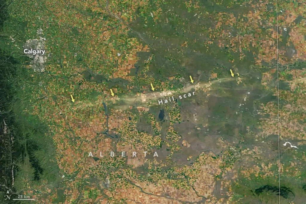
Packing winds of up to 150 kilometres per hour, the storm carved a destructive path from south of Calgary into Saskatchewan, affecting nearly 425,000 acres of insurable crops as well as pasture and native grassland. The storm’s most intense swath, measuring about 15 kilometres wide and 200 kilometres long, stretches from near Vulcan to areas north of Brooks, where damage was most severe.
On the ground, the destruction was described as among the worst in recent memory. Crops were shredded, corn stalks snapped in half, and irrigation pivots overturned. Homes sustained severe structural damage, with siding ripped down to nail points and asphalt shingles stripped bare.
Researchers from the Northern Hail Project (NHP) at Western University, who surveyed the area, concluded that damage north of Brooks represented “among the worst the NHP has documented to date.” Their report noted total crop losses, denuded shrubs, pulverized grasslands, and root systems left exposed.
Cleanup efforts are ongoing. In the days following the storm, volunteers from Mennonite congregations assisted residents in clearing debris and fallen trees. Yet for many, recovery will be long. “I’ve seen a lot of hail damage over the years, but I’ve never seen anything like that,” said farmer Gerald Torkelson of Millicent, Alta. “My yard looks like the moon.”
Farmers are working to salvage what little remains, cutting damaged crops for livestock feed or preparing fields for next season. Ranchers face years of reduced grazing capacity as flattened pastures and exposed root systems slowly recover. “Everything that was there is gone, so it’s a next-year deal, I guess,” said rancher Brad Osadczuk of Jenner, Alta.
Insurance officials warn of widespread claims, with losses considered “devastating” given that most crops had reached maturity. “At this time of year… what’s lost is lost,” said George Kueber, provincial adjusting manager at Agriculture Financial Services Corporation.
Experts emphasize that while satellite images may show regrowth within months, the ecological and economic toll can last years. Barry Adams, a retired rangeland agrologist in Lethbridge, urged producers to reduce or suspend grazing on heavily damaged lands to encourage recovery. “Ranchers will need to monitor their pastures and recognize those areas needing special management to assist recovery,” he said.
Despite the resilience of prairie ecosystems, the storm underscores the vulnerability of agriculture to extreme weather. “It went from beautiful, high-yield crops to basically dirt in the matter of a half an hour,” Osadczuk said, reflecting on the sudden reversal of what had been a promising season following years of drought.