CPEC and Transport Infrastructure

The Karakoram Highway (KKH), also known as the Friendship Highway in China, was built by the Governments of Pakistan and China. Historically it was started in 1959. Pakistan initially favored routing through Mintaka Pass, but in 1966 China recommended it through the steeper Khunjerab Pass of Karakorum mountain range and finally road was opened to the public in 1979.
The Mintaka Pass (elevation15449 feet) is in the Karakorum Mountains, between Pakistan and Xinjiang province of China. In ancient times, the Mintaka Pass was one of the main access points into the upper Hunza Valley from the north.
The Khunjerab Pass (elevation 15,397 feet) is a high mountain pass in the Karakorum Mountains in a strategic position on the northern border of Pakistan’s Gilgit Hunza – Nagar District on the southwest border of the Xinjiang region of China.
The route of the KKH traces back to the one of the many paths of ancient Silk Road, runs from Kashgar, a city in the Xinjiang region of China, to Abbottabad, of Pakistan and then meets the Grand Trunk Road, at Hasan Abdal, In the Gilgit–Baltistan region The highway cuts through the continental collision zone, between the Eurasian and Indian plates, where China, Tajikistan, Afghanistan, and Pakistan come within 250 kilometers of each other so the Karakoram Highway has Geo-strategic and military importance to these nations, but particularly to Pakistan and China.
Strategic development in highway’s network
In 2002, Pakistan’s National Highway Authority (NHA) began construction of the 653 km-long Makran Coastal Highway linking Gwadar with Karachi. In 2003, the Gwadar Industrial Estate was established to promote industrial activities. In 2004, 820-km long M-8 motorway linking Gwadar with Ratodero in Sindh province and onwards with the rest of the Motorways of Pakistan. In 2006, the Gwadar Development Authority adopted a 50-year Master Plan for Gwadar.

In June 2006, a MOU was signed between Pakistan and China to rebuild and upgrade the Karakoram Highway to expanded its width of road from 10 meter to 30 meters , so as to make it all weather road and increase its transport capacity to three times of its existing capacity.
On 4 January 2010, the traffic on KKH was disturbed due massive landslide / earth quick in Hunza valley, created the potentially unstable Attabad Lake, which reached 22 KM in length and over 100 meters in depth. In July 2012 China and Pakistan decided to construct a revised route around the lake at a higher elevation with five new tunnels and bridges.
One Belt One Road (OBOR)
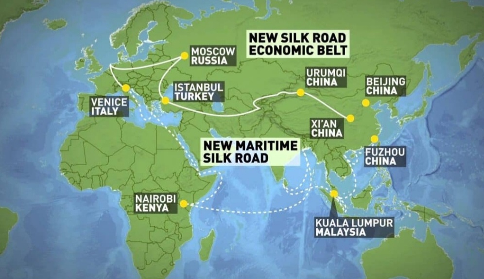
One Belt One Road (OBOR) is a global infrastructure development strategy adopted by the Chinese Government in 2013 based upon the idea proposed by Chinese president Mr. Xi Jinping, for connecting China with the rest of the world for trade and commerce. OBOR was based upon two elements concept. First is the (Silk Road Economic) ‘Belt’ element refers to plans for a revitalized series of ancient overland trading routes connecting China with Europe and Asia to be built largely with Chinese expertise. The central Asia was seen as the most vital region for the ‘Belt’ element. The 2nd element ‘Road’ is outline plans to be additionally establish on new sea trade infrastructure along the old Marco Polo route – a maritime silk road connecting China, Southeast Asia, Africa, and Europe – by incorporating fuelling stations, ports, bridges, industry, and infrastructure through South east Asia and into the Indian Ocean.
Development of “BELT” – Silk route
Pakistan and the China enjoys long lasting and friendly ties since the formal establishment of diplomatic relations, accordingly Pakistan was seen as the most crucial partner country in OBOR ancient silk route belt.
On 5th July 2013 Pakistan and China signed a MOU to link the Karakorum Highway to the southern port of Gwadar in Baluchistan province of Pakistan. This project also ensures the sustainable stability in FATA, Baluchistan and KPK as economic strength ultimately boost the Peace and prosperity in the area.
Belt & Road Initiative (BRI)
As China entered in the new era of geo-economic relationship, an ambitious economic development and commercial project based upon OBOR that focuses on improving connectivity and cooperation among multiple countries spread across the continents of Asia, Africa, and Europe, it become the Belt and Road Initiative of China in 2014 and considered as relatively new term by investing in more than 150 countries and international organizations including Central Asian and Middle East states.

Creation of CPEC
In April 2015, Chinese President Xi Jinping visited Pakistan and announced a commitment for building a network of roads called the China-Pakistan Economic Corridor (CPEC) as Pakistan is the most crucial partner country in China’s Belt & Road Initiative (BRI) – a massive China led infrastructure project that aims to stretch around the globe – It is a project of linking Kashgar in northwest China with Gwadar port on Arabian Sea coastline in the Baluchistan province of Pakistan for trade purpose as well as make a short less costly route towards oil producing & exporting (OPEC) countries. This effort through the China Pakistan Economic Corridor project the things are brightening up for Pakistan.
Linking China & Pakistan (Road link from Khunjerab to Gwadar)
The Karakorum Highway spans the 887 KM long distance between the China-Pakistan border and the town of Burhan, near Hasan Abdal. At Burhan, access onwards existing M1 and M2 motorways, will also be an intersection of the Eastern Alignment, and Western Alignment.
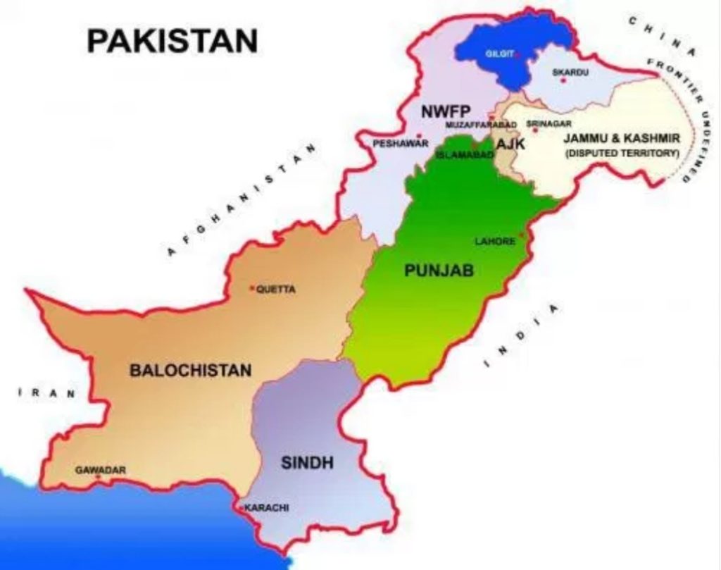
The Key node cites which lies close to this corridor include: Kashgar, Atsushi, Akato, Tajik, Khunjerab, Gilgit, Peshawar, D.I.Khan, Islamabad, Lahore, Multan, Quetta, Sukkar, Hyderabad, Karachi and Gwadar.
CPEC – Eastern Alignment
The term Eastern Alignment of CPEC refers to roadway projects located in Sind and Punjab provinces. As part of the Eastern Alignment, motorway will connect Pakistan’s two largest cities, Karachi and Lahore with Gwadar.
The entire Eastern Alignment motorway project is divided into following parts:-
• Burhan – Lahore
• Lahore – Multan
• Multan – Sukkar
• Sukkar – Hyderabad
• Hyderabad – Karachi
• Karachi – Gwadar
CPEC – Western Alignment
The term Western Alignment of CPEC refers to roadway projects located in KPK and Baluchistan provinces is divided into following parts:-.
• Burhan – Yarik, (just north of D.I.Khan)
• Dera Ismail Khan – Zhob
• Zhob – Quetta.
• Quetta – , Surab
• Surab- Hoshab (near the city of Turbat)
• Hoshab and Gwadar
The alignments will be flanked by special economic zones along its route.
CPEC – Future central alignment
Long-term plans for a “Central Alignment” of the CPEC consist of a network of roads which will commence in Gwadar and travel upcountry via the cities of Basima, Khuzdar, Sukkur, Rajanpur, Layyah, Muzaffargarh, and terminating in Dera Ismail Khan, with onward connections to China Pakistan Economic Corridor route / highway.
CPEC coverage area
China Pakistan economic corridor starting from Kashgar in China reaching Gwadar via Khunjerab pass and several other areas, promoting friendly cooperation while prioritizing development in Gwadar, Energy, Transport infrastructure and industrial cooperation. Its coverage is divided into Core zones and Radiation zones.
Core zones and Radiation zones are part of spatial layout of “One Belt, three axes and several passages” as follow:
• One belt denotes all the major cities lying near the corridor
• Three axes denote the horizontal axes connecting Peshawar, Lahore, Sukkar, Quetta Karachi & Gwadar.
• Several passages refer to several railway, highway, and trunk roads from Islamabad to Karachi and Gwadar.
CPEC Functional zones
The whole corridor from Kashgar to Gwadar is divided into five functional zones from North to South concentrating on node cities, transportation and industrial clusters as follow:
• Xinjiang foreign economic zone
• Northern border trade logistic, business & ecological zone
• Eastern & Central plain economic zone
• Western logistic and business zone
• Southern coastal logistics & business zone
Pakistan’s vision 2025 & CPEC Long term Plan (2017 -2030)
Both plan are considered to be merged as:
• Short term: 2015-2020 (Take initial shape, address bottlenecks)
• Medium term: 2020-2025 (Building basics, industrial & Major economic functions)
• Long term: 2025-2030 (Mechanism for sustainable economic growth in place)
CPEC & Integrated Transportation system:
Transport infrastructure is considered as basic and prerequisite condition for the CPEC, through the join planning of both countries in the field of Highways, Railway, Sea ports and Aviation network along the main nodes cities.
• Road network through Eastern, western and central alignment of road from Khunjrab to Gwadar.
• Capacity expansion of existing Railway lines and construction of new Railway projects in nodes city lying in Core and Radiation zones.
• Construction and development of Gwadar seaport.
• Construction of new Gwadar international airport.
The Impact of CPEC on Pakistan Aviation Industry
CPEC is to open the new horizons of business and employment opportunity. The economic development will lead to increase in volume of Aviation industry in Pakistan with increase in Passengers volume, Cargo Handling and number of aircraft operation at national as well as international sectors.
Pakistan Civil Aviation Authority has made comprehensive plan to improve existing facilities and develop new infrastructure which includes Islamabad new airport, Gwadar new airport, and Thar new airport beside expansion of Quetta, Faisalabad, and Peshawar airports and up gradation of Radar and other flight communication / navigational systems.
Pakistan’s Airports & CPEC
The following are the Airports which fall in the Core zones of CPEC.
Airports of CPEC West alignment:
• Gilgit Airport
• Islamabad International airport
• D.I.Khan airport
• Zhob airport
• Quetta Airport
• Turbat airport
• Gwadar International airport
Airports of CPEC East alignment:
• Gilgat airport
• Islamabad International airport
• Lahore international airport
• Multan airport
• Rahim yar Khan airport
• Sukkar airport
• Hyderabad airport
• Karachi international airport
• Pasni airport
• Gwadar international airport
It is to worth mention that all the airports located in the Core or Radiation zone of CPEC corridor have great potential for tourism besides catering the logistic support, commercial or emergency needs arising in the spatial of CPEC.
Gwadar and Aviation
History of Aviation in Gwadar go back to the invention of aircraft in 1903. After the First World War use of aircrafts for military use considerably increased, accordingly a network of airstrips on all along the costal belt of sub-continent under the command of British Government was made. An airstrip was developed at Gwadar in 1928 as a Postal airstrip to carry the mail of Royal forces.
In 1948 Gwadar acceded to the newly created Dominion of Pakistan and officially became part of Pakistan in 1958, after 200 years of Omani rule. It was given the status of a Tehsil of Makran district.
Pakistan Civil Aviation Department upgraded the postal airstrip as Runway and established the uncontrolled Civil Aerodrome Gwadar which enabled the PIA – the national carrier of Pakistan – to start its domestic flights for Gwadar in 1966 and in 1970 it was given status of international aerodrome to have international flight, so as to cater the need of passenger between Muscat and Gwadar travelling by Oman Air – the air carrier of Sultnate of Oman.
Gwadar International airport
The Gwadar aerodrome was given the status of airport and existing terminal building of Gwadar airport was established in late 1980’s to meet the growing need of the area due establishment of mini sea port and other commercial activities in the area.
New Gwadar international airport
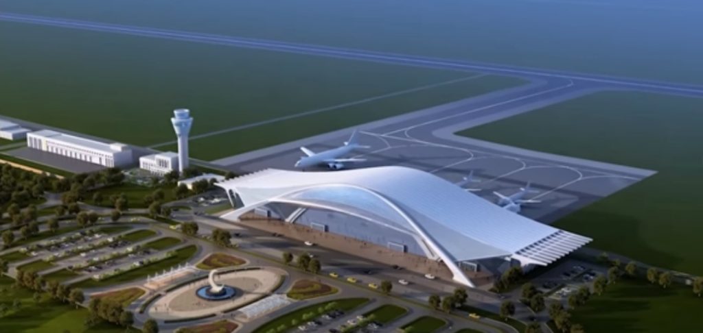
Keeping in view the importance of Gwadar, Government of Pakistan (GOP) as a part of overall development in Baluchistan decided to have an international airport to cater the wide body aircraft, so a new site about 26 KM east of Gwadar port was marked for the new airport covering an area of 4300 acres. On the basis of initial concept design, the Original PC-1 was approved in September 2008 amounting to Rs.7675 million.
In January 2015 GOP decided to have new Gwadar international airport (NGIA) at world class level as per ICAO standers to meet the needs of larger aircraft, i.e. B-777 & A-380 and accordingly approved revised PC-1 amounting to Rs.22 Billion.
NGIA become an important component of CPEC programme and considered to be developed as – Early Harvest High Priority Project – on international standard of category 4F airport, with 100% grant basis from China side.
The airport planned to have 12000 X 200 feet runway and required Load Classification Number (LCN) to cater Airbus 380 category of aircrafts and ILS CAT-1 with night landing facilities. Beside the Passenger terminal and world class modern Cargo terminal with all the required facilities.
In April 2015 three chines company namely, China Communication Construction Company (CCCC), China State Construction Engineering Company (CSECC) and China Aero-Technologies International Corporation (CATIC) nominated to have framework for the construction of Gwadar airport.
As a first step Site protection work and Fence / Parameter track of 18.5 KM with watch towers was build. After getting Environmental Impact & technical operational assessments study report and necessary procedural working, Runway was completed and work on terminal, ATC, Cargo complex fuel farm and other related facility started.
The Construction of New Gwadar International Airport is a significant step towards increasing air passenger travel and cargo handling capacity at par with international standards. It is expected to stimulate the development in Gwadar peninsula and boost trade between Pakistan and China.
The Gwadar Greenfield Airport built across an area of 4,300 acres will be the one of the biggest in Pakistan and will also become the nation’s second airport for Airbus 380 type aircrafts. The Gwadar new airport is set to be completed in September 2023.


